Description of the tasks
1. Scientific and technical project management
Conceptual framework
MONOIL was inspired by the conceptual framework of the Integrated Environmental Assessment (IEA), formed from the GEO approach devised by the United Nations for Environment and Development (UNEP, 2007), inspired itself from the model Driving Forces - Pressure - State-impact - Response developed by the European Environment Agency (Smeets and Weterings, 1999). In MONOIL, oil-drilling activities are the driving forces that cause environmental pressure, hereby contamination (of water, air and soil). This pressure causes environmental degradation, in other words, its quality; these changes to the environment have an impact on the associated society, especially in terms of health (public and animal, etc.) that increase correspondingly with initial social vulnerability (before impact) as well as economic development. Finally, the response reflects the social capacity to cope with these impacts: it is the political, industrial or social measures, whether individual or collective, at local, regional or national levels that aim to regulate, prevent and reduce contamination and/or exposure to contaminants and thus reduce the intensity of impacts. MONOIL will focus on the core of the model (state-impact-response) whereby exploratory work and existing data provided by the partners will enable the study of driving forces and pressures. The specificity of the project lies in its focus on the processes that define the transition from one element to another: for example, to understand the impact of petroleum activities and contamination risk on societies, we will work on both social dispositions (e.g., action strategies) that enable the reduction of exposure to contamination sources but also, at another level, we will focus on the “dose-response” (via the use of biomarkers) that enable an understanding of the scale of the impact that environmental contaminants have on living organisms and human cells (which in turn provides data regarding both their capacity for defense and level of damage). We will question effectiveness and efficiency of certain social responses at different levels: public authorities (hydrocarbon reform bill; PRAS) and civil society (the capacity for political representation, resources for action).
.
Study sites
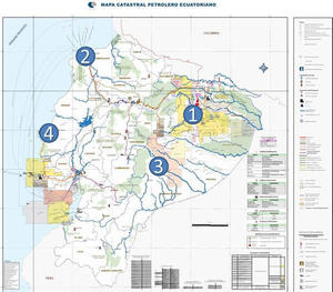
Research will first be conducted on an enlarged territory based on two “parishes” (equivalent to “communes” in France), Dayuma and Pakayacu, which were identified by the Ecuadorian Ministry of Environment as having the highest index of socio-environmental vulnerability for the period 1967 - 2009 in the area under considerable pressure from the oil industry (SIPAS, 2011).
(1) Amazonia
Dayuma: in this parish, the PRAS accounts for an average of 16,840 leaks per thousand inhabitants between 1967 to 2009, with nearly 19 pools and 20 oil spills per 1000 people considered as “poor” between 1967 and 2009 and an average rate of formation waters in the environment of 67,141 barrels per dwelling without access to drinking water in the same period (14,033 barrels per capita). The territory is considered particularly sensitive: 90.8% has been deforested from the first oil drilling in the region, which makes water resources and soil particularly vulnerable to contaminants inputs.
Pakayaku: the authorities that manage the PRAS estimate that an average of 43 092 barrels of formation waters were released into the environment per household, for those with no access to drinking water. It accounts for 9736 barrels of formation waters per capita between 1967 and 2009, some 19 pools and 21 oil leaks for 1000 inhabitants considered as “poor” during the same period. The social vulnerability index is thus very high. In addition, in June 2009, the site was subject to an important leak of formation waters which lasted for fifteen days; site remediation was undertaken at a late stage, rendering environmental consequences still visible. Today, the site is subject of an action plan for the remediation of environmental and social liabilities.
(2) At the request of EP Petroecuador, the site of Esmeraldas national refinery on the Pacific coast is also studied. The refinery, originally constructed in an unpopulated area of the Esmeraldas city, was commissioned in 1967 with the aim of producing petroleum products to meet domestic demand. After its construction, legal and illegal settlements have gradually emerged in the zone of its greatest influence, often with the complicity of the municipal authorities. In addition, even if the refinery does have an environmental management plan (revised in 2009), the city is not prepared for emergencies, despite past experience (including a fire of great scope in 1998). The zone of influence is thus characterised by a conjunction of problems of an environmental, sanitation and safety nature, based on the operation of the refinery.
(3-4) Control areas have also chosen: In Amazonia, the area will be located in the province of Morona-Santiago, in the Santiago River basin (3), near San Jose de Morona, in the southeast of the country: devoid of anthropogenic source of hydrocarbons, or heavy metals, its geographical, geomorphological, ecological and hydrological characteristics are similar to those of the study areas. It is part of a sub-watershed that originates in the Amazon basin. For the Pacific coast, the control area will be located in the province of ManabĂ, in the "Galera San Francisco" a protected area (4).
Figure 2:study sites


